managing multiple spaces |
||||||
|
|
||||||
|
Chapter in Space,
Spatiality and Technology, edited by Phil Turner and Elisabeth Davenport |
||||||
|
This paper is about our experiences of space in the Equator project (www.equator.ac.uk), in particular, the way in which multiple spaces, both virtual and physical, can co-exist. By this we mean that people and objects may have locations in and relationships to both physical space and one or more virtual spaces, and that these different spaces together interact to give an overall system behaviour and user experience. The concepts we develop in this chapter are driven partly by practical experience, and partly by previous theoretical work such as the models and taxonomies of spatial context in (Dix et al., 2000), the models for mixed reality boundaries (Koleva et al., 1999) and capturing human spatial understanding exposed in sources such maps, myths and mathematics (Dix, 2000). We are also building on established work on informal reasoning about space from the AI and GIS communities (Grigni et al, 1995; Papadias et al., 1996) similar to Allen’s well known temporal relations (Allen, 1991).
keywords: spatial models, augmented reality, mobile interfaces, location-aware systems
Within Equator are a number of ‘experience projects’. These are sub-projects focused around the creation of a particular event or outcome, which allow the integration of practical and theoretical work of many kinds. The focus of Equator as a whole is the confluence of physical and digital life and so unsurprisingly the nature of space has been important in many of these projects. We will mention a few here.
The City project allows participants who may be present in person, through VR or through a simple web interface to all ‘share’ a visit to the Mackintosh Room at the Lighthouse in Glasgow. As well as the physical space of the museum there is a digital reproduction of it for the VR users and a map view used by all. The VR visitor has a very precisely known ‘position’ within the virtual room, whereas the web visitor only has a position determined by the current web page – corresponding to a zone and sub-set of exhibits within the physical room. The real visitors of course have a precise position known to them, but this is sensed using ultrasound, which has varying degrees of accuracy (and also coverage black spots within the physical space). So there are at least 5 spaces that impinge upon the user not to mention various coordinate spaces used internally within the software.
In the CityWide project participants play a game within an urban environment where they chase characters within a virtual city. The virtual and physical spaces are overlaid as if there were an invisible ghostly realm behind the surface of buildings and streets. Again varying degrees of accuracy of the GPS sensors used to track the physical participants mean that the measured locations available to the virtual participants may not represent truly the actual physical locations.
The Drift Table, part of the Equator work on domestic environments, is a coffee table with a small porthole in the middle through which can be viewed an aerial view of the whole UK. Weight on different sides of the table makes it drift, like a balloon, over the country. When the table was installed in a real home, the ‘owner’ augmented the table with a road map and used this to help guide the table to specific locations, thus adding the road map's spatial model to the physical space in the room and the virtual space in the porthole ... which is of course itself a photograph of the real physical space of the UK.
Finally in Ambient Wood, school children wander around a wood in Sussex on a ‘digitally enhanced fieldtrip’ and take readings with a light and humidity sensor. The location of their readings are recorded so that they can be shown later collected together on a map of the wood. Also as they move through the wood there are wireless hot spots; when the children enter them sounds or other events are triggered.
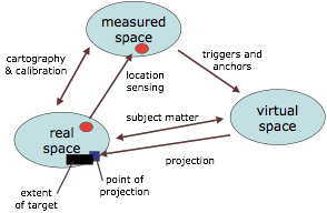
Although we usually think of relating physical space and virtual space in augmented reality, there are in fact three types of space to consider:
Note that virtual spaces may themselves be models of real world things (e.g. an architect’s walkthrough, the virtual Mack room, aerial photographs in the Drift table), but this differs in intent from a similar representation used to track locations of real objects.
These three types of space are related in different ways.
• mapping – the representation of the real space will involve some cartographic process of measuring points and their relations, either against a global system (e.g. GPS) or relative to one another (e.g. theodolite or simple tape measure)
• location sensing – this will involve issues of accuracy (e.g. GPS errors range from less than a metre to tens of metres), and also areas where location cannot be sensed at all (e.g. ultrasound in the Mack room was shadowed by some exhibits)
• triggers – events (collisions, entering active anchor areas as in Ambient Wood, proximity) may trigger actions in the virtual world. Note that as these are triggering electronic world events they will normally (always) be triggered from representations of the objects and space in the measured spaces rather than directly by the physical space (arguably something like triggering by physical contact would be a counter-example).
• identity – the same measurements of a real space may be used to construct a virtual space (e.g. real Mack room -> VR version)
Note that the penultimate example would also be true if the video wall was projecting a web-cam picture – that is projection can also be a property of themeasured–real spatial relationship.
As we saw in the examples earlier, it is not that we have a single measured, real and virtual space, but typically several of each. Even physical space has different characteristics depending on perspective: "in this room", as opposed to "near Aunty Mo" or "at 37.32E, 12.56N".
Notice also how this location information is of very different kinds:
Furthermore, measured spaces differ in both accuracy and extent. For example, the ultrasound location in the Mack room only has meaning within the room and even then has voids in information booths that create an ultrasound shadow.
In fact, people are remarkably adept at dealing with these multiple spaces. In CityWide the participants made use of areas where the GPS coverage was poor in order to ‘hide’. Also some of the physical visitors in the Mack room, when they entered one of the information booths, would hold their PDA, in which was the location sensor, at arms length outside the booth. This gave the remote participants a more accurate view of the physical participant’s location (albeit being portrayed just outside the booth). As we saw the user of the Drift Table brought maps and atlases into the experience – choosing voluntarily to add yet more spaces.
Computationally things are more difficult!
In mathematics differential geometry deals with spaces that are curved or broken in ways such that no single coordinate system can cover them. Instead a patchwork of overlapping coordinate systems are used with mappings in the areas of overlap. A similar technique is used in VR systems so that two rooms may have separate VR models which are linked at the doorway by a local mapping between the coordinate systems.
Note however that in both these case the partial spaces are Cartesian and also that the mapping is largely fixed. Unfortunately, neither are necessarily true in the digitally enhanced environments we are considering.
In order to explore these issues further we have been using rich scenarios. For example, considering a series of stories about train travel has enabled us to explore issues where a local coordinate system (the location within the train) moves relative another coordinate system (the track and stations) and is not even of constant shape (the train bends).
In brief, we have seen how experiences with digitally enhanced environments reveal multiple interacting spaces. We distinguished physical, measured and virtual spaces and saw how each can be of several kinds and differ in accuracy and extent. People deal remarkable well with complex special relationships, but it is harder for mere computers! In order to understand the mappings between these complex spaces we have been using scenarios to explore different types of space, complementing our more practical observations.
[1] J.F. Allen (1991). Planning as Temporal Reasoning. In Proc., 2nd Principles
of Knowledge Representation and Reasoning, Morgan Kaufmann.
[2] A. Dix, T. Rodden, N. Davies, J. Trevor, A. Friday and K. Palfreyman (2000).
Exploiting space and location as a design framework for interactive mobile systems.
ACM Transactions on Computer-Human Interaction (TOCHI), 7(3), pp. 285-321.
[3] A. Dix (2000). Welsh Mathematician walks in Cyberspace (the cartography
of cyberspace). (keynote) Proc. of the Third International Conf. on Collaborative
Virtual Environments - CVE2000. ACM Press. pp. 3-7.
[4] M. Grigni, D. Papadias and C. Papadimitriou (1995). Topological Inference. Proceedings of the International Joint Conference of Artificial Intelligence
(IJCAI 1991), Montreal, Canada, AAAI Press.
[5] B. Koleva, S. Benford and C. Greenhalgh. The Properties of Mixed Reality
Boundaries. Proceedings of ECSCW’99., 1999.
[6] D. Papadias, M. Egenhofer and J. Sharma (1996). Hierarchical Reasoning about
Direction Relations . Proceedings of the 4th ACM-GIS. ACM Press.
Alan Dix 26/1/2005